Ship Rendezvous Calculation For Chief Mate
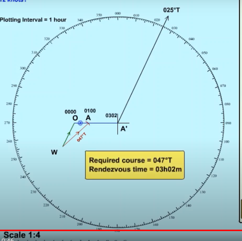
Your vessel has a maximum speed of 16 knots. What course must you steer to rendezvous as soon as possible with another vessel at present 20 miles due east of you and which is steering 025 degrees true at 12 knots?
Your vessel has a maximum speed of 16 knots. What course must you steer to rendezvous as soon as possible with another vessel at present 20 miles due east of you and which is steering 025 degrees true at 12 knots?
First of all, decide the range scale of the plot. Here, in this example, a range scale of 1:4 is used.
Now, Plot the vessel whose course and speed is known in the center position of the plotting sheet. In this question, it is the other vessel that is steering 025 degrees True course at 12-knot speed.
Plot the bearing and distance between two vessels (OA’). In this example, The other vessel is 20 miles due east of your vessel or your vessel is 20 miles due west of that vessel. So plot accordingly.
Choose the appropriate plotting interval. 1-hour plotting interval will be appropriate for this plot.
Plot other vessel’s vector line WO. (1 hour)
Using own vessel’s maximum speed plot WA. (1 hour)
Using OA, relative speed, calculate the time of rendezvous.
Remember, in radar plotting calculation WO is the own vessel’s vector line because own vessel is always in the center of the plotting sheet.
+++++++++++++++++++++++++++++++++
Ship Rendezvous Calculation For Chief Mate
Vessel “X” receives a call for assistance from the vessel “Y” at 0800 hours. Vessel “Y” has a fire on board and is bearing 220° Tx 48 nautical miles from vessel “X”. Vessel “Y” is steaming at 12 knots on a course of 270° T, because of an easterly wind. If the maximum speed of “X is 24 knots, what course must it set to rendezvous at the earliest time? What is the ETA of “X” at the rendezvous position?
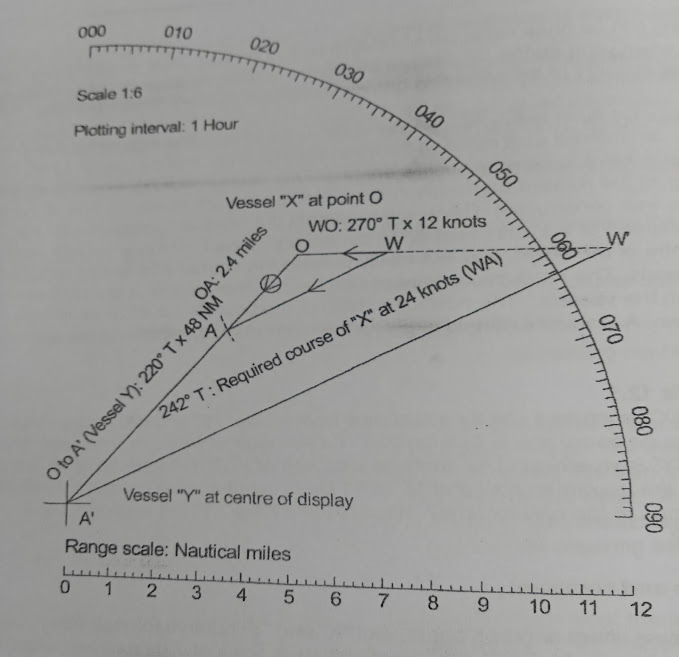
On a plotting sheet, plot “X” and “Y” relative to each other, using
an appropriate scale. For this example, a scale of 1:6 has been used.
If using a radar plotting sheet, plot vessel “Y” at the center (point A’) and then vessel “X”, such that “Y” is 220°T x 48 nm from “X”. “Y” is moving at a steady course of 270° T @ 12 knots.
Choose a plotting interval. For this first plot, one hour has been used.
Produce “WO” and link it to “O”, such that “WO” is 270° T and 12 miles (2 miles on the plot). 12 nm represents the distance traveled by “Y” in one hour.
Using a distance of 24 miles, i.e. the distance traveled by “X” in one hour, draw an arc from “W on the “OA” line. Join “W” to “A”. Determine the direction of “WA”.
WA” is the course to steer by “X” to rendezvous with “Y” at the earliest time. From the plot, the course is 242° T.
The time of rendezvous can be best determined by using the relative approach speed “OA”. From the plot distance “OA” is 14 .4 nm. The total distance of OA’ is 48.0 nm. The distance OA is covered in one hour, so the total time can be determined:
Time to R/V = (OA’ / OA) x Plotting interval
= (48 / 14.4) x 1
= 3 hours 20 minutes
0800+ Time to RV
= ETA at Rendezvous
0800+0320
= 1120
In some cases, the geographical position of the two vessels may be known, rather than the bearing and distance.
